Expansion Sparks of Istanbul ...
Expansion Sparks of Istanbul
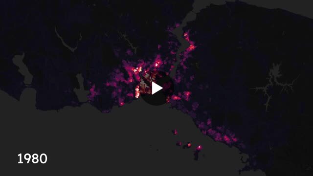
Here is the estimated spatiotemporal distribution of “new” building density from 1980 to 2020. You can take a look at the interactive map at https://lnkd.in/dUaunTTa Pre-1980: Old Istanbul Before 1980, the city was concentrated around central districts such as Fatih, Beyoğlu, Kadıköy, Beykoz, and Şişli. However, migration began pushing growth outward into areas like Zeytinburnu, Şişli, Bağcılar, Esenler, and Gaziosmanpaşa, leading to the emergence of informal settlements.
1980-2000: Neoliberal Sprawl With rapid industrialization and economic liberalization, migration surged, fueling unregulated housing growth. The city expanded outward, with dense construction occurring in the west (Zeytinburnu, Bağcılar, Bahçelievler, Küçükçekmece, Esenyurt) and in the east (Ümraniye, Sultanbeyli, Çekmeköy, Pendik). Informal housing spread as industrial and residential areas merged chaotically. Many of these districts are now the focus of urban renewal projects.
After 2000: New Istanbul The city has become multi-centered, with large-scale housing developments, luxury residences, and ongoing urban transformation projects. Infrastructure investments like metro and Marmaray have improved accessibility, extending the city’s reach into suburban areas. While horizontal expansion has slowed, outer districts continue to densify. Today the effects of planned projects like Kanal Istanbul remain uncertain.
Originally posted on LinkedIn.